IELTS Writing – Chorleywood Village
ELTS WRITING TASK 1
You should spend about 20 minutes on this task.
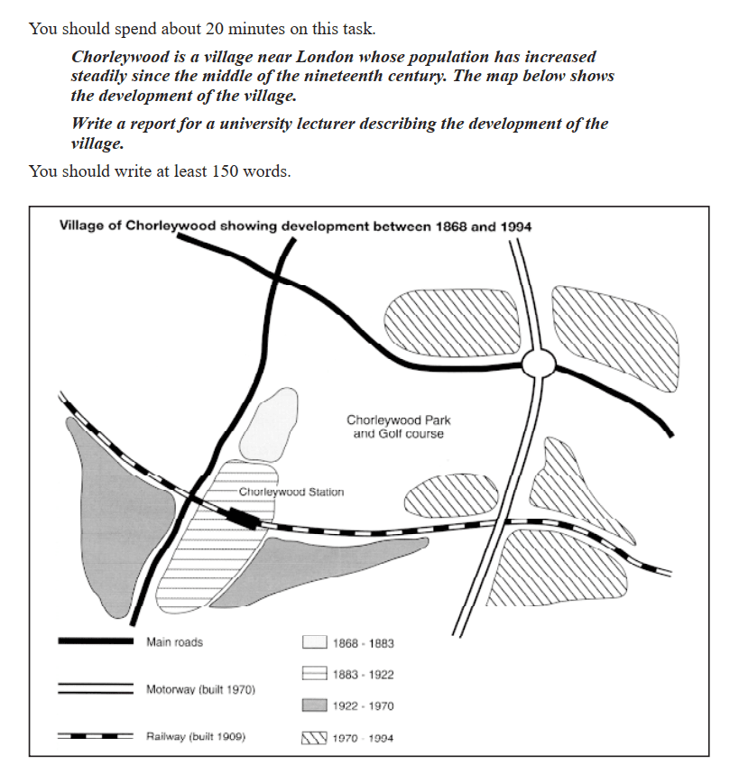
Chorleywood is a village near London whose population has increased steadily since the middle of the nineteenth century. The map below shows the development of the village.
You should write at least 150 words.
Source: Cambridge 01 – Test 04 –
Pre-Writing Details
One challenging part of reading maps is that not everyone is familiar with them, and they can be overwhelming due to the amount of information. One approach to simplify map reading is to start from the center and work outward.
In this case, we will focus on the center of the map, specifically Chroleywood Park and Golf Course. Although there is no compass, we can still identify the directions—north, south, east, and west. Starting from the center, we will move outward to understand the map better. Additionally, we will pay attention to the northwest side, where two main roads are interconnected.
IELTS Writing – Chorleywood Village – Version 01
The map shows the changes in Chorleywood, a village near London, and how the roads and routes changed from 1868 to 1994. Overall, the different roads connected and created various communities.
The village originally had two main roads. The first road ran from the northwestern part of the village to the east. The second road went from the northwestern part to the southwest. These two roads intersected in the northern area. By 1909, a railway was built running from the west to the east. By 1970, a motorway was created in the northeastern part of the village, extending to the southeast. This motorway connected the main road and the railway on the eastern side.
In the middle of the map is Chorleywood Park and Golf Course, which was established between 1868 and 1883. The Chorleywood Station is located at the southwestern intersection of the railway and the main road. From 1922 to 1970, the neighboring area to the southwest expanded. The area close to the motorway, railway, and main road intersection on the eastern side was expanded from 1970 to 1994.
IELTS Writing – Chorleywood Village – Version 02
The map shows the village of Chorleywood, located near London, and illustrates its development from 1868 to 1994. In general, over nearly a hundred years, the village experienced significant expansion with the creation of multiple roads and routes.
Chorleywood Park and Golf Course is situated at the center of the village. In the upper northwest part of the village, two main roads are prominent. The first road runs from the upper northwest, heading east, while the second road intersects from the upper west, extending down to the southwestern part of the village. A railway was introduced in 1909, stretching from the western part of the village to the lower east. This railway connects with one of the main roads. Additionally, a motorway built in 1970 runs from the upper eastern part of the village to the southern part, cutting off the connection between the main road and the railway.
During the expansion, a small area was developed near the western part of Chorleywood Park and Golf Course, close to the southern main road. From 1883 to 1922, further expansion occurred in the area around the intersection of the southern main road and the western railway. Between 1922 and 1970, this expansion extended further east and west. From 1970 to 1994, there was notable development near the intersection of the main road, railway, and motorway on the eastern side.
Check our partners at IELTS Rizz and Educatorian.
Check our other IELTS Writing