IELTS Writing – Island Before and After
IELTS Writing Task 1 Academic – Island Before and After Construction
Source: Cambridge IELTS 09 Test 01.
The two maps below show an island, before and after the construction of some tourist facilities.
Summarise the information by selecting and reporting the main features, and make comparisons where relevant. Write at least 150 words.
Write at least 150 words.
IELTS Writing Task 1 Academic – Island Before and After Construction: Analysis
Data: Multiple Maps
Time: Past
Vocabulary:
– Tourist – Visitors
– Facilities – amenities
IELTS Writing Task 1 Academic – Island Before and After Construction V1
Paragraph 01 – Introduction and Overview / Paragraph 02 – Before / Paragraph 03 – After
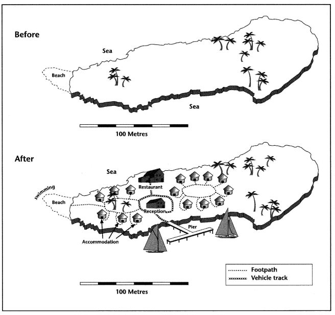
The first map depicts the island’s natural state without any man-made structures, while the second map illustrates the facilities constructed for tourism. Overall, although the landmass is greater on the eastern side, the facilities are concentrated on the western side.
The total length of the island is approximately 250 meters, with a beach situated on the western side adorned with a few trees. The land area is smaller compared to its eastern counterpart. The central part of the island lacks trees, while most of them are found on the eastern side.
Post-construction, the beach on the western side was transformed into a swimming area for tourists, and a footpath connects it to the six nipa-hut-style accommodations. In the middle of the island, the reception is located, and to the north is a restaurant, while the southern part features the T-shaped pier. Additionally, there are nine additional nipa-hut-style accommodations, but they are not connected to the rest of the buildings. (159 Words)
IELTS Writing Task 1 Academic – Island Before and After Construction V2
Paragraph 01 – Introduction and Overview / Paragraph 02 – Pier to restaurant / Paragraph 03 – East and West
The first map depicts the island’s natural state without any man-made structures. While the second map illustrates the facilities constructed for tourism. Overall, although the landmass is greater on the eastern side, the facilities are concentrated on the western side.
The entrance to the island is at the southern middle part, where tourists can sail to the T-shaped pier and anchor their sail. From the pier, tourists can use their vehicles to travel north, reaching the reception located at the center of the island, and further north is a restaurant.
On the eastern part of the island, the beach has been transformed into a swimming area for tourists, and a footpath connects the beach to the six nipa hut-style accommodations. Additionally, nine more nipa hut-style accommodations can be found near the reception, although they are not connected to the main road path. The eastern side of the island remains untouched. (150 Words)
Check Educatorian and IELTS Rizz
Check Tasks 1